MestalaMestala
HomePlacesMapTripBlogAboutFAQ
EN|БГ

Discover Bulgaria with Mestala.

AboutFAQLicensePrivacy
Lakatnik Rocks
MountainsSofia Province

Lakatnik Rocks

HomePlacesMountainsLakatnik Rocks
Coordinates: 43.08871, 23.38210
View on OpenStreetMapGet directions

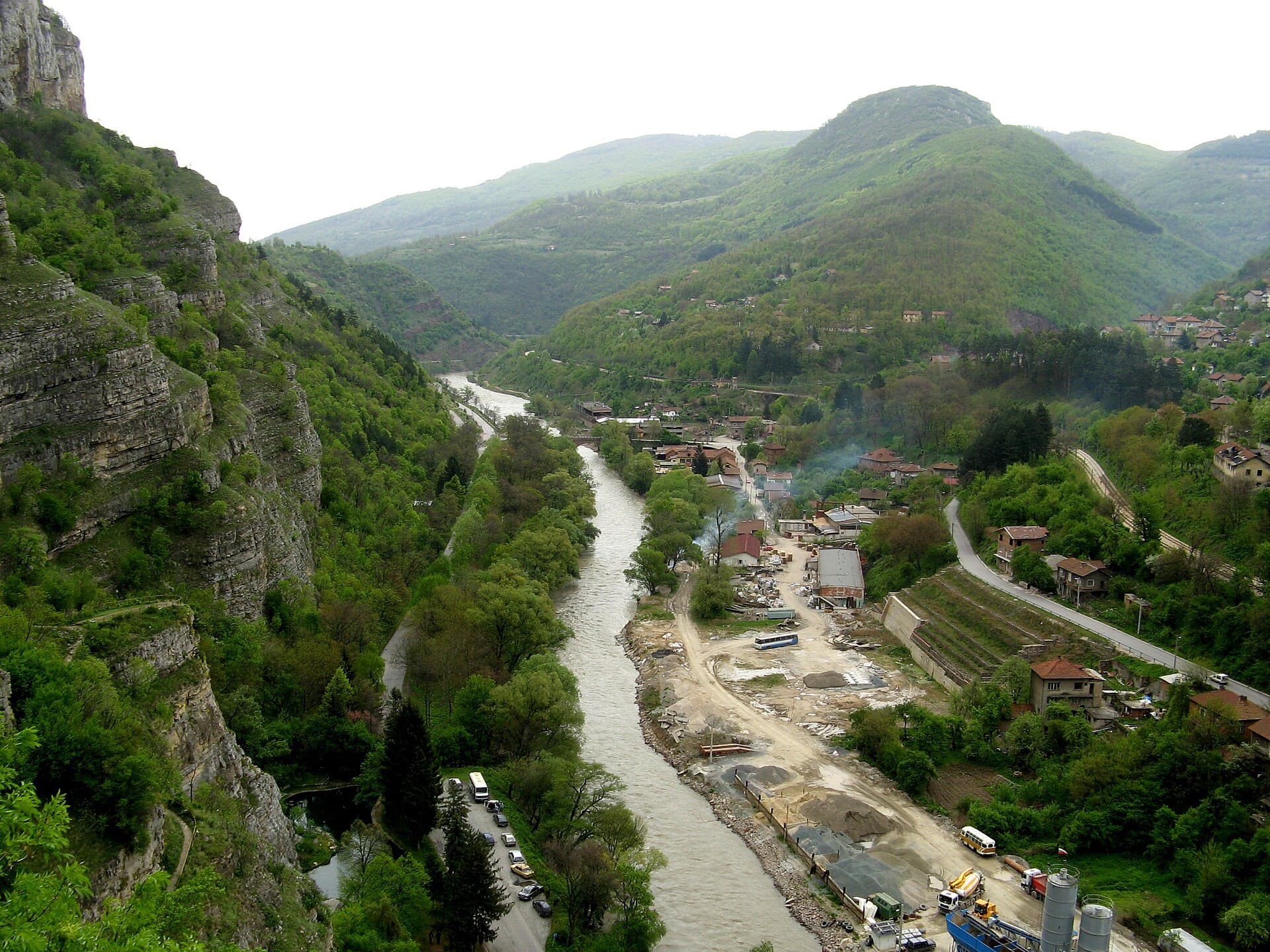
Rising sheer above the left bank of the Iskar River in the Balkan Mountains, the Lakatnik Rocks (Lakatnishki skali) stand as one of Bulgaria's most striking geological landmarks. Located in the Svoge Municipality opposite Lakatnik Train Station, these towering red sandstone and limestone cliffs plunge more than 250 meters down to the riverbed. Millennia of natural erosion have sculpted the massif into dramatic rock towers, jagged pinnacles, arches, and deep karst caves. The Birthplace of Bulgarian Climbing & Caving Lakatnik Rocks hold a storied status in Bulgarian outdoor history as the undisputed birthplace of Bulgarian sport climbing and mountaineering, while its vast cavern networks served as the training ground for generations of speleologists. - "Eagle's Nest" Alpine Shelter (Orlovo Gnezdo): The famous tiny red wooden cabin perched impossibly on a sheer vertical cliff face was originally constructed by climbers in 1938 (and fully restored in 2000). It remains clearly visible from passing trains in the gorge below. - The Climbers' Memorial Cross: Erected in 1939 atop the highest ridge of the cliffs to commemorate fallen mountaineers and climbers. Nearby sits a historic memorial monument overlooking the gorge. Cave Systems & Zhitolyub Karst Spring The Lakatnik plateau features an extraordinarily rich karst landscape with numerous caves, including Razhishkata, Zidankata, and Svinskata Dupka: - Temnata Dupka Cave ("The Dark Hole"): One of Bulgaria's longest subterranean systems, stretching over 9,000 meters in explored length. Spread across four levels, it features a complex labyrinth of subterranean rivers, waterfalls, siphons, and underground lakes. - Zhitolyub Karst Spring: The subterranean waters flowing through Temnata Dupka burst forth at the base of the cliffs right beside the main gorge road, feeding into a tranquil artificial lake and resting area. Useful Visitor Information - Location: Iskar Gorge, Svoge Municipality (approx. 60 km north of Sofia). - Accessibility: Easily reachable by car along the scenic Sofia–Svodge–Mezdra road or by train (get off at Lakatnik Station and cross the pedestrian footbridge over the Iskar River). - Hiking Trail: A steep but well-secured eco-trail leads from the Zhitolyub spring all the way up to the summit cross and the Eagle's Nest viewpoint. - Trip Tip: Perfect for a day trip from Sofia, hiking, sport climbing, or photography. A parking area and local restaurant are conveniently located at the trailhead near Zhitolyub spring.

7-day forecast

Weather data from MET Norway

Nearby Places

red bar
Trails

red bar

Sofia Province

0.1 km away

Temnata Dupka Cave
Caves

Temnata Dupka Cave

Sofia Province

0.2 km away

Razhishka peshtera
Caves

Razhishka peshtera

Sofia Province

0.3 km away

Kozarska cave
Caves

Kozarska cave

Sofia Province

0.9 km away

More to explore

Musala
Mountains

Musala

Sofia Province

Ravni chal
Mountains

Ravni chal

Sofia Province

Glavinitsa
Mountains

Glavinitsa

Sofia Province

Golyam Bliznak
Mountains

Golyam Bliznak

Sofia Province

Read more in our travel guides

Day Trip to Iskar Gorge from Sofia by Train: Sights & Guide

Day Trip to Iskar Gorge from Sofia by Train: Sights & Guide

Discover the Iskar Gorge north of Sofia: Visit the Lakatnik Rocks, Cherepish Monastery, the Ritlite formation, and ride the scenic Sofia–Mezdra railway.
9 August 20265 min read
North-West Bulgaria Road Trip: 4-Day Itinerary & Driving Guide

North-West Bulgaria Road Trip: 4-Day Itinerary & Driving Guide

A complete 4-day road trip itinerary through Bulgaria's least-visited region: Iskar Gorge, Vratsa, God's Bridge, Chiprovtsi, Belogradchik Rocks, Magura Cave, and Vidin.

9 August 20266 min read
Vratsa & Ledenika Cave: Bulgaria's Overlooked North-West

Vratsa & Ledenika Cave: Bulgaria's Overlooked North-West

A travel guide to Vratsa: the Vratsata gorge and its 400-metre rock face, the Ledenika show cave, the Rogozen Treasure of 165 silver vessels, and the Botev memorial at Okolchitsa — an hour and a half from Sofia.

9 August 20266 min read

Frequently asked questions

Where is Lakatnik Rocks located?

Lakatnik Rocks is located in Sofia Province, Bulgaria.

How do I get to Lakatnik Rocks?

Lakatnik Rocks is most easily reached by car. Use the coordinates above to navigate, or open the location in OpenStreetMap or your preferred maps app for turn-by-turn directions. Public transport options vary by region — for remote destinations a rental car gives the most flexibility.

What is the best time to visit Lakatnik Rocks?

Late spring through early autumn (May–September) is best for Lakatnik Rocks, when trails are clear of snow and weather is most stable. Higher peaks may hold snow into June and see fresh snow as early as October. Winter visits are for experienced mountaineers with proper gear.

What should I bring when visiting Lakatnik Rocks?

Hiking boots, layered clothing, water (1.5–2 L per person), sun protection, and a windproof jacket — mountain weather changes quickly. For longer routes also bring a map (paper or offline), a head torch, and emergency rations. Tell someone your planned route and expected return time.