MestalaMestala
HomePlacesMapTripBlogAboutFAQ
EN|БГ

Discover Bulgaria with Mestala.

AboutFAQLicensePrivacy
Ritlite
MountainsVratsa

Ritlite

HomePlacesMountainsRitlite
Coordinates: 43.10763, 23.61561
View on OpenStreetMapGet directions

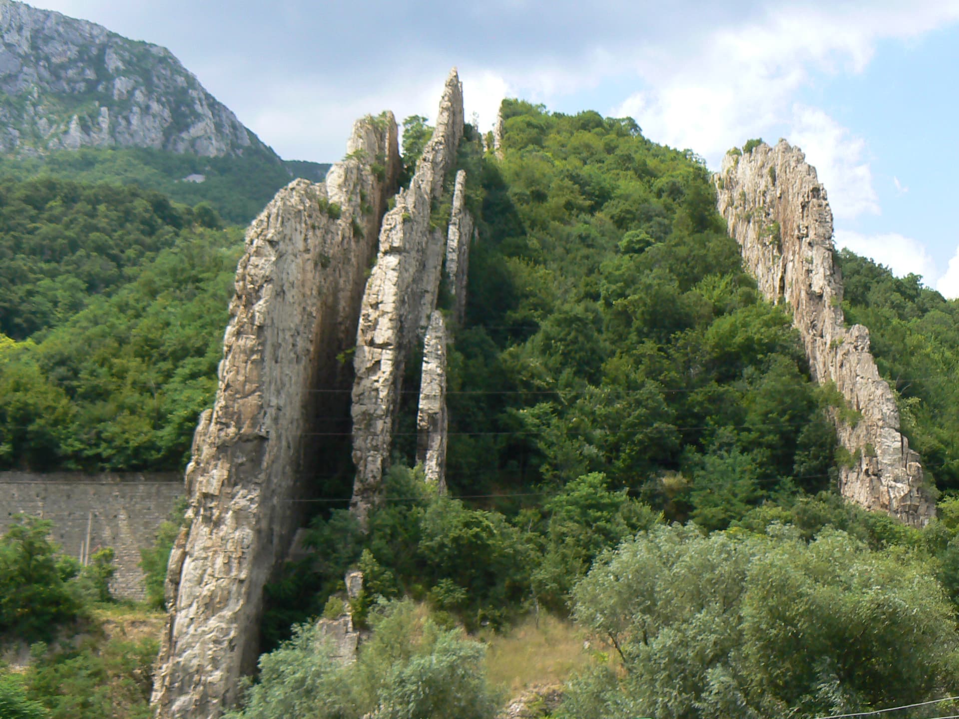
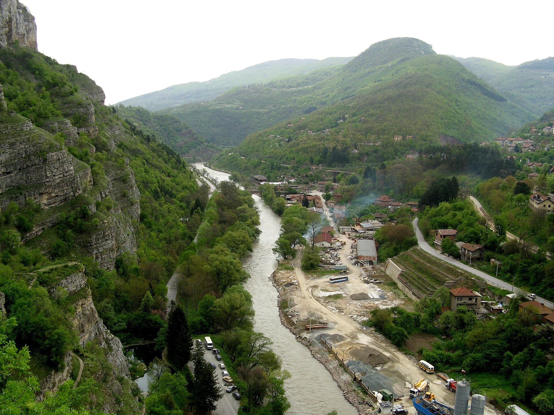
Soaring dramatically near the northern entrance of the Iskar Gorge, right beside the village of Lyutibrod, the "Ritlite" stand among Bulgaria's most striking and unique geological landmarks. Designated as an official Natural Landmark, these massive parallel limestone walls frame the Iskar River, acting as a gateway to the Vrachanski Balkan Nature Park. The name "Ritlite" stems from the rocks' uncanny resemblance to the vertical wooden side-slats (ritli) of traditional Bulgarian wooden oxcarts. Geological Origins & Dimensions The origins of Ritlite date back over 120 million years (Early Cretaceous era) when the surrounding region lay submerged under a warm primeval sea. Over millions of years, thick layers of calcium-rich sediment accumulated on the seabed. Later, during the tectonic folding that raised the Alpine-Himalayan mountain belt, these horizontal seabed layers were uplifted into near-vertical stone slabs. - Left Bank Formations: The most imposing features are four distinct parallel rock walls on the left bank of the Iskar River. They reach sheer heights of up to 80 meters above the river, with wall thicknesses ranging from 3 to 7 meters and stretching 200 to 400 meters in length. - Right Bank: The formation continues across onto the right riverbank, though those ridges are significantly smaller and less pronounced. - Flora: The corridors between the vertical rock walls are carpeted with dense deciduous foliage, creating a stunning visual contrast against the pale limestone walls. Historic Heritage The area surrounding Ritlite has been inhabited since ancient times. Nearby lie the archaeological ruins of the medieval fortress town of Koriten, a 5th-century Early Christian basilica, and ancient road fortifications that guarded the Iskar Gorge passage for centuries. Useful Visitor Information - Location: Next to Lyutibrod village, Mezdra Municipality, Vratsa Province (along the main Sofia–Svoge–Mezdra road). - Accessibility: Easily visible directly from the highway and the Balkan railway line. A dedicated scenic viewpoint, parking area, and rest stop are located on the left bank. - Nearby Attractions: Located just 3 km away from the famous Cherepish Monastery of the Dormition of the Mother of God and the historic Rashov Dol site. - Trip Tip: Ritlite is a must-visit photo stop when driving through the Iskar Gorge. Pair your visit with a trip to Cherepish Monastery or a scenic hiking tour in the Vrachanski Balkan Mountains.
7-day forecast

Weather data from MET Norway

Nearby Places

Eco trail White Rocks
Trails

Eco trail White Rocks

Vratsa

0.4 km away

Eco Trail - Prosechen Kamik
Trails

Eco Trail - Prosechen Kamik

Vratsa

1.4 km away

Vazov kat
Museums

Vazov kat

Vratsa

1.5 km away

Cherepish Monastery
Landmarks

Cherepish Monastery

Vratsa

1.5 km away

More to explore

Sveti Duh
Mountains

Sveti Duh

Vratsa

Tranliviya peak
Mountains

Tranliviya peak

Vratsa

Svetogorski kamak
Mountains

Svetogorski kamak

Vratsa

Salamanova mogila
Mountains

Salamanova mogila

Vratsa

Read more in our travel guides

Day Trip to Iskar Gorge from Sofia by Train: Sights & Guide

Day Trip to Iskar Gorge from Sofia by Train: Sights & Guide

Discover the Iskar Gorge north of Sofia: Visit the Lakatnik Rocks, Cherepish Monastery, the Ritlite formation, and ride the scenic Sofia–Mezdra railway.
9 August 20265 min read
North-West Bulgaria Road Trip: 4-Day Itinerary & Driving Guide

North-West Bulgaria Road Trip: 4-Day Itinerary & Driving Guide

A complete 4-day road trip itinerary through Bulgaria's least-visited region: Iskar Gorge, Vratsa, God's Bridge, Chiprovtsi, Belogradchik Rocks, Magura Cave, and Vidin.

9 August 20266 min read

Frequently asked questions

Where is Ritlite located?

Ritlite is located in Vratsa, Bulgaria.

How do I get to Ritlite?

Ritlite is most easily reached by car. Use the coordinates above to navigate, or open the location in OpenStreetMap or your preferred maps app for turn-by-turn directions. Public transport options vary by region — for remote destinations a rental car gives the most flexibility.

What is the best time to visit Ritlite?

Late spring through early autumn (May–September) is best for Ritlite, when trails are clear of snow and weather is most stable. Higher peaks may hold snow into June and see fresh snow as early as October. Winter visits are for experienced mountaineers with proper gear.

What should I bring when visiting Ritlite?

Hiking boots, layered clothing, water (1.5–2 L per person), sun protection, and a windproof jacket — mountain weather changes quickly. For longer routes also bring a map (paper or offline), a head torch, and emergency rations. Tell someone your planned route and expected return time.