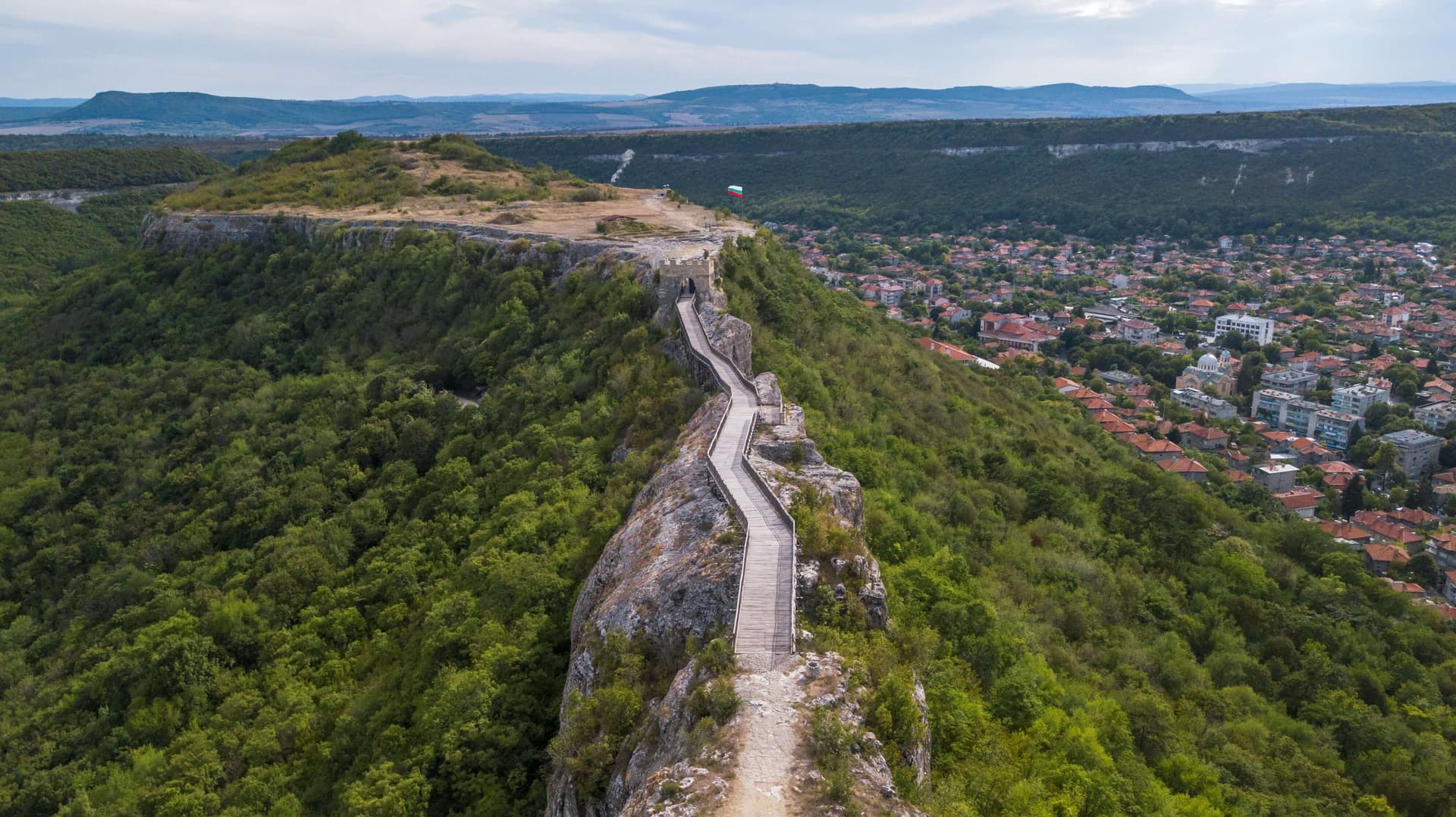
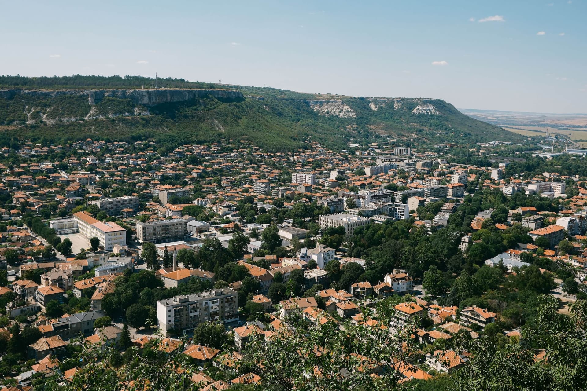
The Ovech Fortress is a monumental medieval stronghold situated immediately east of the contemporary town of Provadia. It occupies an expansive and strategic high plateau overlooking the urban valley, which bears the popular name Kaleto across local folklore and scientific literature. Due to its long-standing history and spectacular defensive military engineering, Ovech operates as a premier destination for cultural-historical and ecological tourism across Northeastern Bulgaria. Historical Chronology and Nomenclature of the Stronghold Archaeological evaluations prove that the rocky plateau was settled during ancient historical epochs, registering a strong Thracian presence centuries prior to the Christian Era. The fortress itself was initially engineered by the military architects of the Roman Empire, operating actively as an imperial outpost from the 4th century until the early 7th century AD. Following this early phase, the fortification remained inactive for nearly a century. The subsequent intensive resettlement of the site commenced during the 11th century and finalized at the absolute close of the 17th century, tracking the structural decline of the Ottoman military-administrative apparatus. Over the centuries, the fortress held a key position within international trade chronicles and was designated under separate names by various cultures: - Byzantine Title: Eastern Roman chroniclers referred to the stronghold as Provat or Provaton. - Bulgarian Title: Medieval Bulgarians designated the citadel under the authentic name Ovech. - Ottoman Title: Turkish conquering forces named the asset Tash Hisar, which translates literally as the stone fortress. - Arabic Chronicles: Within the extensive historical and cartographic documents compiled during the 12th century by the celebrated Arab traveler Al-Idrisi, the fortress is recorded under the nomenclature of Burfanto. Ovech achieved its highest political, military, and cultural peak during the Second Bulgarian Kingdom, transforming into one of the most powerful, impregnable, and critically vital fortresses across Eastern Bulgaria. Specific Topography and Fortification Parameters The fortress occupies a unique plateau whose structural layout strikingly resembles a colossal ship oriented along the axis from north to south. From all imaginable angles, this natural plateau is densely enclosed by vertical rock crests displaying a height measuring from 11 to 25 meters. The stronghold is anchored upon an elevated rock terrace rising 130 meters above the surrounding terrain, with 30 meters of that displacement consisting of completely vertical, inaccessible cliffs. Natural entry to the plateau in the past was restricted to a single, narrow rock ledge measuring 50 meters in length and a width of merely two human paces. To maximize security parameters, a deep defensive ditch measuring 4 to 5 meters in depth and 8 to 10 meters in width was excavated into this rock ledge, spanned by a massive wooden drawbridge. A narrow isthmus links the ship-shaped plateau with the adjacent Tabiiete plateau, positioned immediate to it in a northern direction. High, thick curtain walls rose across the northern sector of Kaleto, where the Main Gate of the citadel was positioned. It was logistically linked with the neck of the Tabiiete plateau via a monumental wooden bridge facility extending roughly 160 meters in length. Operating over an artificially excavated ditch placed right in front of the gateway - measuring 8 meters long and 5 meters deep - was a secondary defensive drawbridge. Immediate to the Main Gate initiates a highway carved into the solid rock, masterfully vaulted for over ten meters, guiding travelers into the inner fortress courtyard. Rising at the center of the main plateau is a secondary, smaller interior terrace with a height of 7 to 8 meters, which historians suggest housed the primary defensive citadel of the governor. Strategic Role and Connectivity to the Coastline A primary catalyst for Ovech receiving such extensive urban and military development under the rule of Bulgarian monarchs was its close geographical proximity to the major maritime port of Varna. Throughout medieval history, the Bulgarian state lacked a permanent and powerful naval fleet capable of engaging the Byzantine navy in open waters. Consequently, the city of Varna remained vulnerable to naval incursions and naval artillery bombardments launched by Byzantine ships. Within this defensive framework, Ovech was developed and fortified to operate as a premium tactical outpost and military base, shielding the medieval Bulgarian capitals of Pliska, Preslav, and Tarnovgrad from deep Byzantine land invasions. Old local legends narrate that the massive karst caves cutting beneath the fortress floor guarded strategic state reserves of grain, wheat, and cured provisions. These resources successfully sustained the town's population across consecutive months during extended enemy sieges. Excavated Archaeological Remnants Today Today, the territory of the architectural-historical reserve is fully integrated for tourism, offering visitors an array of perfectly preserved and conserved landmarks: - Bridging Facility: The fully reconstructed wooden bridge infrastructure spanning between the fortress and the adjacent Tabiiete plateau, unlocking panoramic views over Provadia. - Water Harvesting: Numerous deep wells designed to catch rainwater, including one striking structure reaching a record depth of 80 meters, carved entirely into the solid rock face. - Storage Structures: Deep stone cisterns and specialized silos engineered for secure grain storage. - Ecclesiastical Architecture: The ruins of a grand three-nave, single-apsed metropolitan cathedral that functioned as the spiritual capital of the medieval Diocese of Ovech, alongside the remnants of two smaller single-nave, single-apsed churches dating between the 12th and 14th centuries. - Military Assets: The stone Northern Gate, authentic watchtowers, and military guardrooms. - Judicial Infrastructure: Preserved subterranean dungeons engineered for medieval nobles, alongside specialized cells holding citizens convicted of crimes, public offenders, and captured foreign prisoners of war. - Epigraphic Monuments: The precious marble columns of the Bulgarian Khan Omurtag featuring incised inscriptions. - Ancient Caves: Natural cave recesses that were continuously settled by humans since the Classical Antiquity epoch.

Varna
0.6 km away
Varna
0.7 km away

Varna
2.2 km away
Varna
10.2 km away
Ovech Fortress is located in Varna, Bulgaria.
Ovech Fortress is most easily reached by car. Use the coordinates above to navigate, or open the location in OpenStreetMap or your preferred maps app for turn-by-turn directions. Public transport options vary by region — for remote destinations a rental car gives the most flexibility.
Ovech Fortress can be visited year-round. Spring and autumn offer the most pleasant conditions for exploring, with mild temperatures and fewer crowds. Summer is ideal for photography and longer day trips; winter visits are possible but weather can limit access at some sites.
Most natural landmarks in Bulgaria are freely accessible and open year-round, though some sites have entrance fees or require a guide. Wear sturdy footwear and bring water, as the terrain can be uneven. Respect any protective barriers and stay on marked paths to preserve the site.