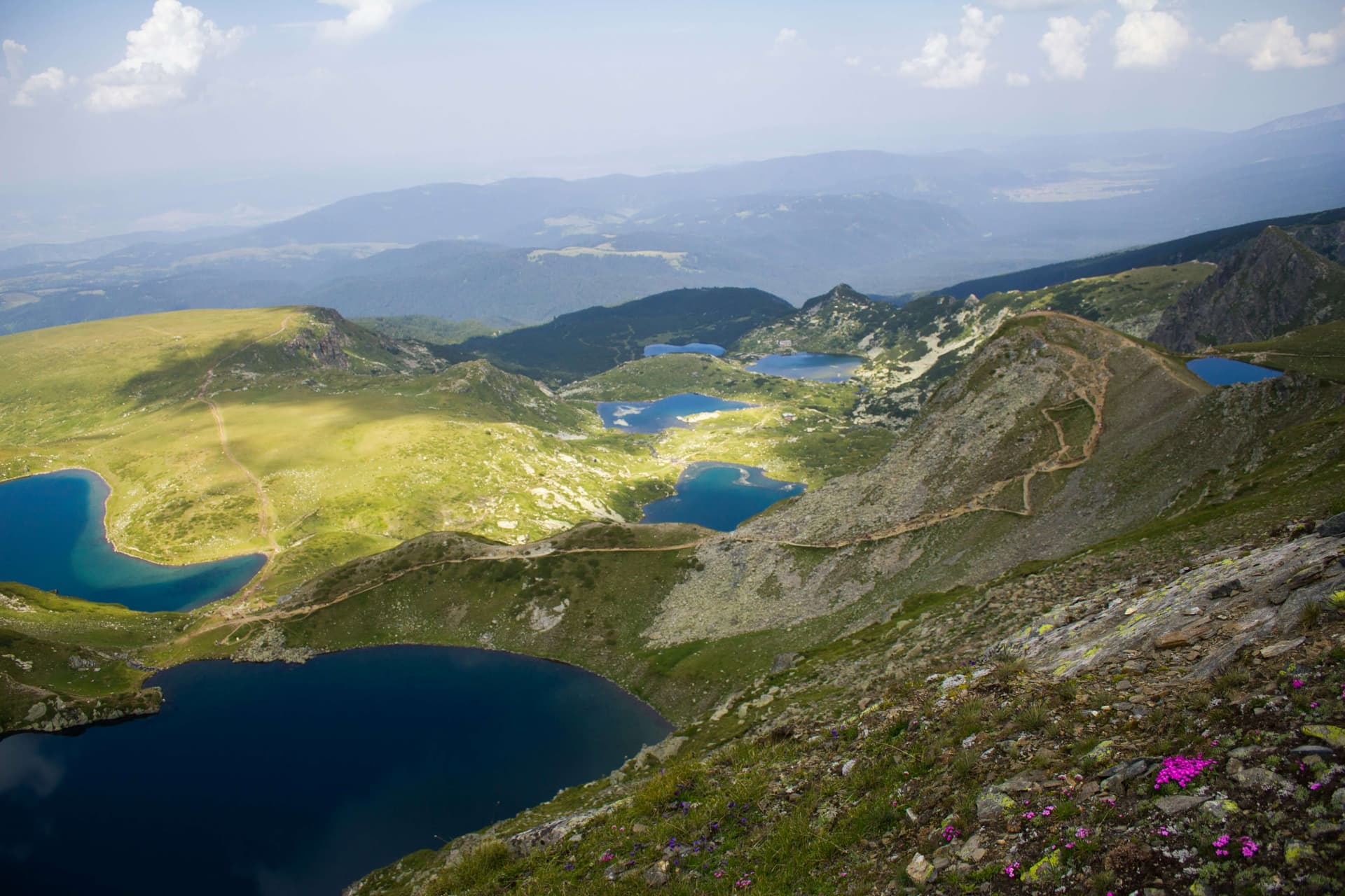
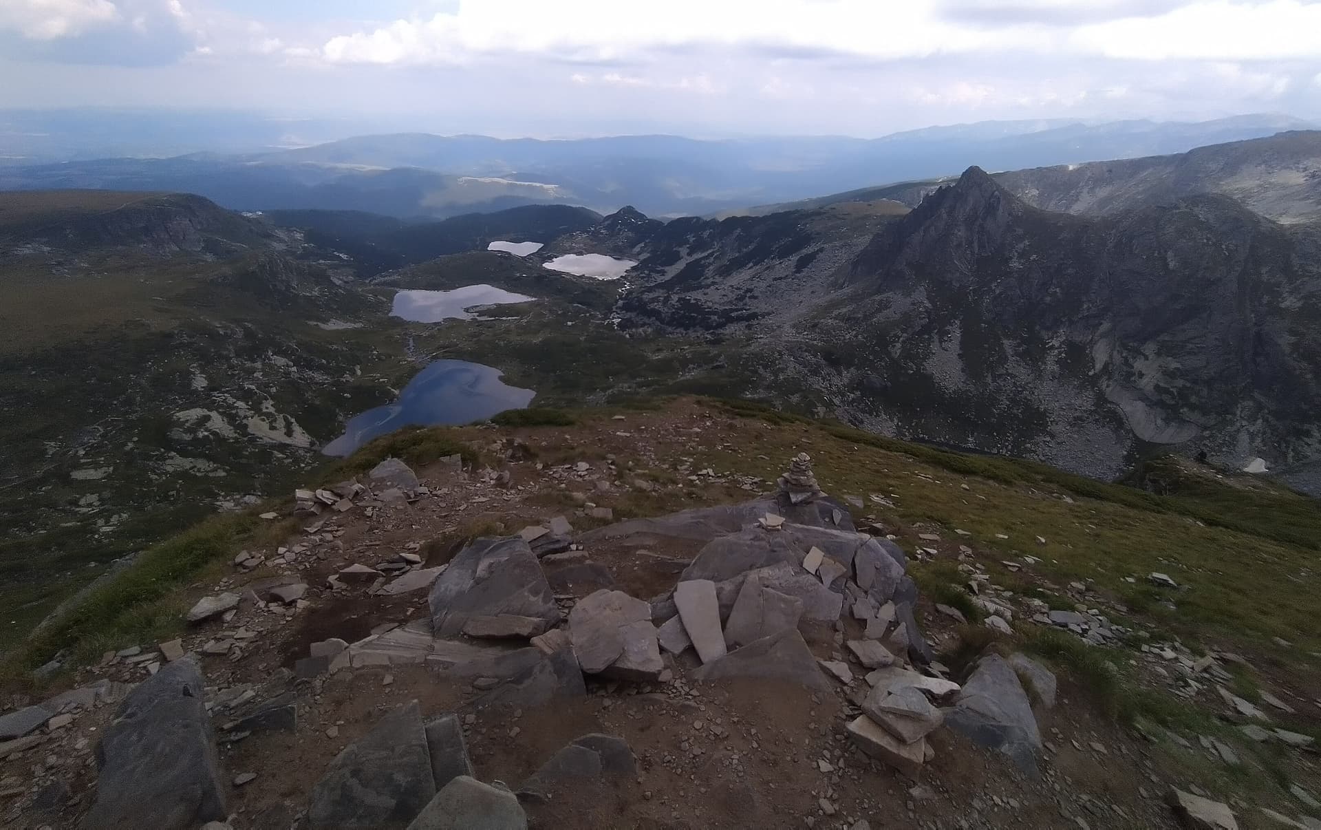
The Seven Rila Lakes represent an iconic and globally renowned group of lakes of distinct glacial origin, situated high within the Rila Mountains. It stands officially as the most visited group of lakes by domestic and international travelers within the Republic of Bulgaria, with the site being integrated under a designated honorary number into the prestigious list of the 100 National Tourist Sites compiled by the Bulgarian Tourist Union. Geographical Location and Hydrological System The unique glacial lakes are located in the scenic Damga ridge of Northwestern Rila. They are situated in a terraced, step-like formation along the mountain slope within a wide altitudinal range between 2095 and 2535 meters above sea level. The water basins occupy deep natural depressions (cirques) along the alpine slope, with the individual lakes logistically connected to one another through a network of small, clear mountain streams. As the water volume passes over these steep streams, beautiful small cascades, rapids, and mountain waterfalls have been formed over centuries. Specifics of the Water Drainage Flow: - The first three lakes: The Tear (Salzata) Lake, The Eye (Okoto) Lake, and The Kidney (Babreka) Lake each drain independently through separate water streams into the lower-lying Twin (Bliznaka) Lake. - Subsequent water highway: From The Twin Lake, the collected water mass flows sequentially through the basins of The Trefoil (Trilistnika) Lake, The Fish (Ribnoto) Lake, and The Lower (Dolnoto) Lake. - Origin of the Dzherman River: A significantly more powerful and high-volume stream flows through the last two lakes (The Fish and The Lower). Exiting the lowest-lying Lower Lake, this stream officially forms the starting point of the mountain Dzherman River, which operates as a major left tributary of the Struma River. Individual Characteristics and Dimensions of the Lakes The official contemporary name of each of the Seven Rila Lakes directly reflects a specific exterior morphological or physical characteristic of the respective water basin: - Salzata (The Tear) Lake: Positioned at the highest altitude within the mountain cirque. It carries this poetic name due to the exceptional, crystal-clear transparency and purity of its deep waters. - Okoto (The Eye) Lake: The next highest lake along the mountain incline is The Eye Lake, which in older historical texts is also found under the name The Heart due to its distinct, approximately oval shape. The Eye holds the status of being the absolute deepest cirque lake across all of Bulgaria, with its researched depth reaching an impressive 37.5 meters. - Babreka (The Kidney) Lake: Engineered with specific natural contours that closely resemble a human kidney. This is the lake distinguished by having the steepest, rockiest, and most heavily eroded shores of the entire mountain group. - Bliznaka (The Twin) Lake: This represents the fourth consecutive lake by altitude along the trail. The Twin is officially the largest lake by surface area among the seven, and during dry summer seasons, it splits into two smaller connected water basins. - Trilistnika (The Trefoil) Lake: Situated further down the terraced mountain slope, distinguished by its pronounced irregular shape and relatively low shores. - Ribnoto (The Fish) Lake: This stands officially as the shallowest lake within the entire glacial group. Constructed on its grassy northeastern shore is the old Seven Rila Lakes mountain hut. - Dolnoto (The Lower) Lake: Positioned at the lowest altitudinal tier of the group, gathering the descending waters from the upper basins to formally give rise to the Dzherman River. Historical Nomenclature in the Past In the recent historical past, the entire terraced mountain cirque of the Seven Lakes and the lake group itself were known among the local population by the Turkish name Yedi Gol, while the water basins were referred to as the Yedigolski Lakes. The individual water bodies carried old names completely distinct from modern ones: - Salzata Lake was historically called Bash Gol. - Okoto Lake was recognized as Chanak Gol. - Babreka Lake carried the name Kara Gol. - Bliznaka Lake was referred to as Chifte Gol. - Trilistnika Lake was recorded as the Sredniya (Middle) Gol. The last two lowest lakes - Ribnoto Lake and Dolnoto Lake - did not possess any individual personal names in the past. Popular Tourist Trails to the Lakes Access to the Seven Rila Lakes is highly facilitated through several established mountain trails initiating from different base locations: - Route via the town of Sapareva Banya: Travelers depart from the town of Sapareva Banya along a maintained asphalt highway until reaching the Pionerska mountain hut. From the Pionerska hut, an open chairlift carries hikers directly to the modern Rilski Ezera mountain hut, where the main walking trails commence. - Route via Govedartsi Village and Vada Hut: Travelers depart from Govedartsi village along an asphalt road to the Vada mountain hut, where a marked forest trail initiates toward the Rilski Ezera hut. - Route via the Malyovitsa Ridge: Travelers depart from Govedartsi village along an asphalt road to the territory of the famous Malyovitsa Resort Complex. From there, hikers cross past the Malyovitsa mountain hut and navigate a high-altitude ridge path to reach the area of the Rilski Ezera hut. The Ancient Myth of the Origin of the Lakes The old folklore legend of the Seven Rila Lakes narrates that thousands of years ago, when human beings did not yet exist on Earth, two loving giants - a man and a woman - inhabited the wild nature of the Rila Mountains. They loved each other passionately and truly worshiped the raw beauty, silence, and comfort of their shared mountain home. Their home was so appealing, sunny, warm, and cozy that it charmed every living creature, while their pure love was sincerely celebrated by all natural elements and the entire world. Unfortunately, one day, evil and destructive forces passed close to their mountain home. Upon witnessing this magical and beautiful location, they felt immense envy toward the family happiness of the two giants, became enraged, and decided to destroy everything to erase their love forever. The evil forces began sending thick black clouds, thunder, and devastating winds over Rila. Terrifying earthquakes shook the earth's crust. The young male giant fiercely defended every blade of green grass, every small clear stream, and every flower, shielding his beloved with his body and successfully repelling the heavy attacks of the evil forces. However, this only fueled their immense malice and cruelty further, and they decided to finish their wicked plot to the absolute end. In one of these severe battles, the young giant was killed in a valley. Satisfied with their victory, the evil forces departed, leaving behind only shattered rocks, ruined valleys, and a woman completely devastated by sorrow and grief. The grief of the young widow was so immeasurable that tears poured from her eyes ceaselessly, flowing down the steep mountain ridges straight into the low valleys. They poured continuously and gathered in the hollows until they fully formed today's clear lakes of astonishing purity and blue color. Mountain guides point out to tourists, immediately before reaching The Kidney Lake, a massive natural rock structure standing in the direction of the highest lake, Salzata. The physical shape of this rock closely resembles the embracing figures of a man and a woman of enormous dimensions. According to popular legend, these are the two giant lovers who will remain petrified here to eternally guard their beautiful mountain home.

Kyustendil
0.9 km away
Kyustendil
1.6 km away
Kyustendil
1.6 km away
Kyustendil
1.9 km away
Which Bulgarian network to pick, whether you need a SIM at all as an EU visitor, eSIM options, passport rules, and where coverage actually drops.
Looking for travel ideas? Discover the 15 most beautiful and iconic landmarks in Bulgaria—from the Rila Lakes to Plovdiv Old Town and Belogradchik.
A comprehensive travel guide to Bulgaria's weather and seasons. Discover the best time for beach vacations, skiing in Bansko, wine tours, or hiking high mountain peaks.
Seven Rila Lakes is located in Kyustendil, Bulgaria.
Seven Rila Lakes is most easily reached by car. Use the coordinates above to navigate, or open the location in OpenStreetMap or your preferred maps app for turn-by-turn directions. Public transport options vary by region — for remote destinations a rental car gives the most flexibility.
Seven Rila Lakes is best walked from May through October, when the trail is clear of snow and weather is generally stable. Summer middays can be hot at lower altitudes — start early. Winter walking requires proper gear and route knowledge.
Suitability depends on the specific route. Bulgarian trails range from paved family-friendly paths to multi-day high-mountain crossings. Check the length, elevation gain, and surface before setting off. Sturdy footwear, water, and a basic map (offline or paper) are essential even on short walks.