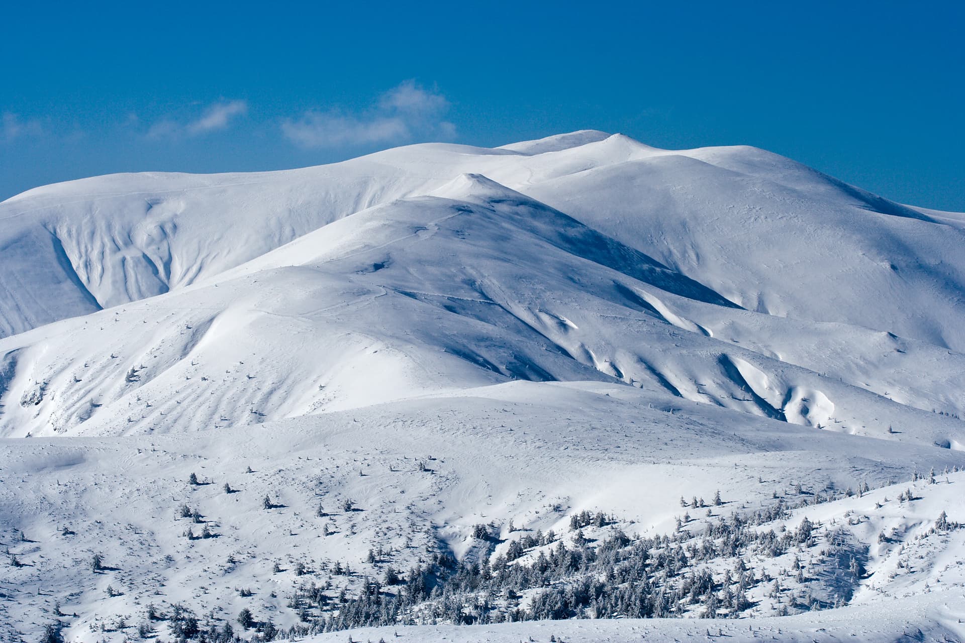
Mount Rilets (2,713 m), widely feared in the past under its historical names Dzhendema (The Hell) and Smradlivia Chal (The Stinky Peak), is the highest summit of the Rilets Ridge in Central Rila. In 1942, the peak was renamed to honor the legendary National Revival master builder Alexi Rilets. Resembling a colossal granite pyramid surrounded by dense dwarf pine and unstable boulder fields, it remains one of the most rugged and inaccessible alpine terrains in Bulgaria. Terrain and Alpine Challenges The peak is notorious for its severe topography and presents serious navigational challenges: - Unstable Moraines: The ridge and the summit dome are blanketed in vast fields of loose, massive granite boulders, requiring steady footing and experience. - The Bush Barrier: The rock fields are frequently interrupted by impenetrable belts of dwarf pine (klek), a feature that earned the area its medieval Ottoman name Dzhendema (meaning "hell" or "the abyss"). - Winter Mountaineering: In winter conditions, ascending Rilets transforms into a high-difficulty alpine climb that strictly requires ice axes, crampons, and proper rope securing techniques. A Hydrological Crossroads Rilets serves as a major watershed separating the valleys of the Rilska and Iliyna rivers. The ridge is flanked by an impressive system of glacial lakes: - The Eastern Slope: Shelters Smradlivoto Ezero (The Stinky Lake), which holds the title of the largest glacial lake on the Balkan Peninsula. - The Southwest Base: Home to the remote and mystical Dyavolski (Devil's) Lakes. - The Northern Terrace: Trapped between two secondary ridges lies Chernoto Ezero (The Black Lake), before the mountain drops sharply toward the Rilska River. The summit rewards those who conquer it with an outstanding, unobstructed panorama toward the jagged peaks of the Malyovitsa region to the northwest.

Kyustendil
1.6 km away
Kyustendil
3.1 km away
Kyustendil
3.7 km away
Sofia Province
3.9 km away
Rilets is located in Kyustendil, Bulgaria.
Rilets is most easily reached by car. Use the coordinates above to navigate, or open the location in OpenStreetMap or your preferred maps app for turn-by-turn directions. Public transport options vary by region — for remote destinations a rental car gives the most flexibility.
Late spring through early autumn (May–September) is best for Rilets, when trails are clear of snow and weather is most stable. Higher peaks may hold snow into June and see fresh snow as early as October. Winter visits are for experienced mountaineers with proper gear.
Rilets reaches an elevation of 2,713 metres above sea level.
Hiking boots, layered clothing, water (1.5–2 L per person), sun protection, and a windproof jacket — mountain weather changes quickly. For longer routes also bring a map (paper or offline), a head torch, and emergency rations. Tell someone your planned route and expected return time.