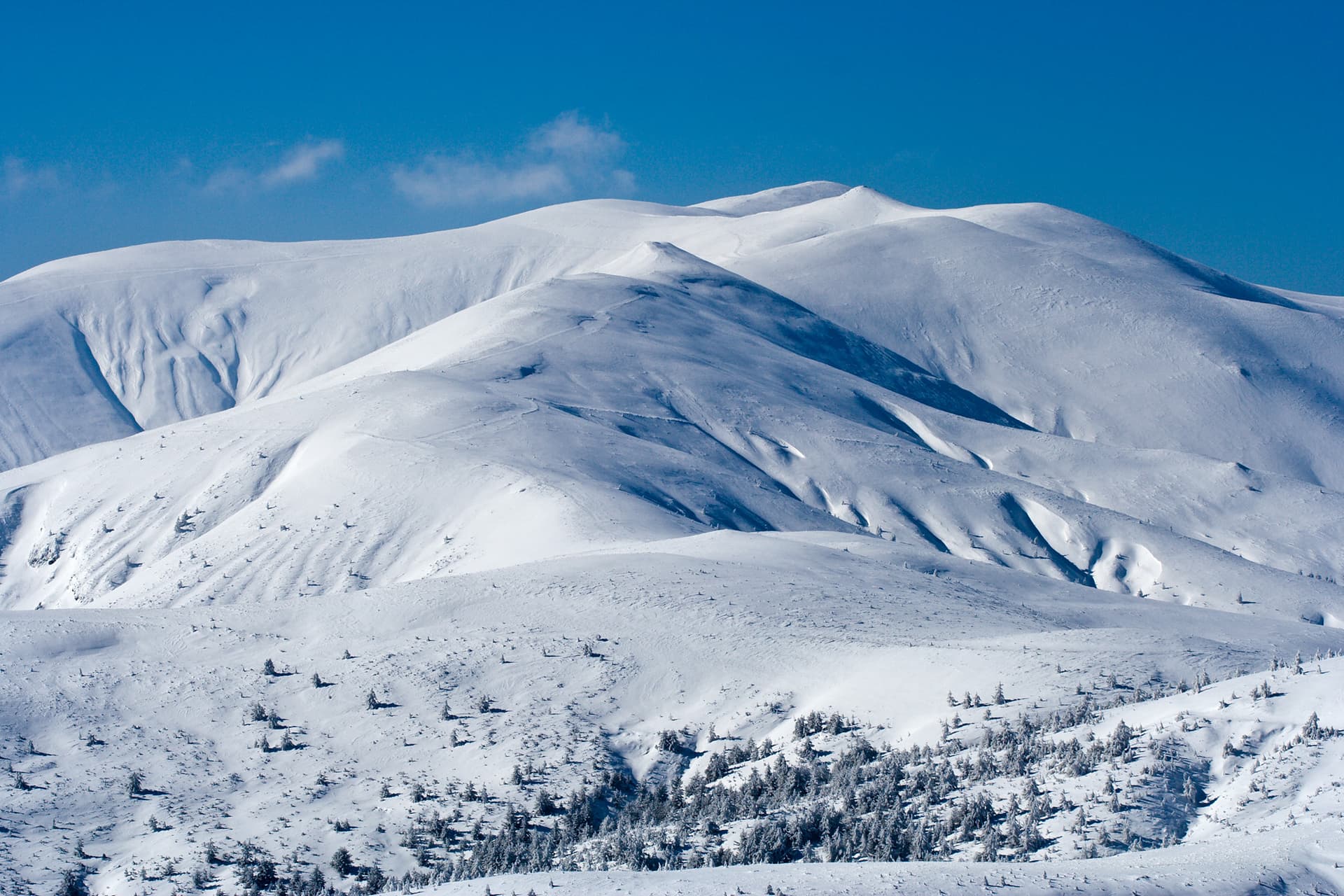
Mount Golyam Mechi Vrah (Great Bear Peak) is one of the most popular, open, and massive summits in the Southwestern part of the Rila Mountains. Rising prominently along the northern ridge of this region, the peak stands out as a premier destination for high-mountain trekking. Nestled at its southern foothills is the key mountain pass of Mechi Prohod, home to the Macedonia Mountain Hut - a vital hub and basecamp for routes leading deeper into the alpine zones of Rila. Until 1942, the peak bore the historical name Ay Gidik, a name that can still be found in vintage hiking guides and older maps of the area. A Key Hydrographic Hub in the Rhodope-Rila Massif The massive ridge of Golyam Mechi Vrah functions as an essential hydrographic junction for Southwestern Rila. The Kodzhakaritsa and Radovichka rivers both originate from its northern and western slopes, later flowing as left tributaries into the Iliyna River. From the high saddle near the macedonia hut emerges the Blagoevgradska Bistritsa River. This river gathers waters from numerous streams across the southwestern ridges, maintaining a steady westward course before emptying into the Struma River near the city of Blagoevgrad. Conversely, heading east from the Mechi Prohod saddle is the source of the Dinkov Dol River, which joins the Belishka River before ultimately feeding into the Mesta River near the village of Kraishte. Technical Trail Parameters: - Starting Point: Kartalska Polyana area (accessible via an asphalt road from Blagoevgrad). - Major Intermediate Point: Macedonia Mountain Hut. - Total Trail Distance: 9.3 kilometers. - Elevation Gain: 1162 meters. - Total Duration: Approximately 4 hours one way. Safety Advice and Winter Navigation Notes: This high-altitude description outlines a classic summer trek. During winter, when a thick snowpack covers the mountain, the steep grassy slopes require extreme caution. The ascent from the hut up to the ridge must strictly follow the winter steel trail poles (winter marking). Deviating from the marked poles is highly dangerous due to terrain hazards. For winter ridge traverses, hikers must strictly stay on the crest line. Because of the substantial elevation gain, if you do not plan to spend the night at Macedonia Hut, it is vital to start the hike early during stable weather conditions to ensure enough daylight for a safe return. Detailed Step-by-Step Hiking Route Description Stage 1: From Kartalska Polyana to Macedonia Hut The trek starts at the Kartalska Polyana area, which marks the end of the paved asphalt road leading up from Blagoevgrad. Several wooden picnic gazebos serve as the official trailhead. From this spot, follow the well-marked trail heading east, tracking upstream against the current of the Blagoevgradska Bistritsa River. The hike through the river valley features a gentle, steady incline and reaches Macedonia Hut within approximately 2 hours and 30 minutes. Stage 2: Climbing from the Hut to the Unnamed Elevation Following a rest break at the hut, the main ascent toward Golyam Mechi Vrah begins. The trail pushes straight north, rapidly gaining altitude as it climbs the steep, grassy southern slopes of the mountain. Follow the winter trail marker poles closely. After about 1 hour and 10 minutes of intense uphill hiking, you will arrive at the base of an unnamed intermediate elevation. At this point, the primary summer trail options switch right toward the northeast. You must leave that main path, climbing directly up the slope of the elevation to reach its small crest. Stage 3: Across the Saddle to the Stone Cairn From the crest of the unnamed elevation, begin a brief and easy descent heading west toward the shallow saddle that connects it to the main peak. Navigate carefully through a few short, easy rocky sections. Just 10 minutes after leaving the intermediate hill, you will arrive at the absolute summit of Golyam Mechi Vrah. Marking the highest point is a large, distinctive stone cairn, offering hikers a spectacular 360-degree panoramic view over the rugged ridges of Rila, the distant Pirin peaks, and the Struma River valley below.

Blagoevgrad
2.5 km away
Blagoevgrad
3.4 km away
Blagoevgrad
3.4 km away
Golyam Mechi vrah is located in Kyustendil, Bulgaria.
Golyam Mechi vrah is most easily reached by car. Use the coordinates above to navigate, or open the location in OpenStreetMap or your preferred maps app for turn-by-turn directions. Public transport options vary by region — for remote destinations a rental car gives the most flexibility.
Late spring through early autumn (May–September) is best for Golyam Mechi vrah, when trails are clear of snow and weather is most stable. Higher peaks may hold snow into June and see fresh snow as early as October. Winter visits are for experienced mountaineers with proper gear.
Golyam Mechi vrah reaches an elevation of 2,619 metres above sea level.
Hiking boots, layered clothing, water (1.5–2 L per person), sun protection, and a windproof jacket — mountain weather changes quickly. For longer routes also bring a map (paper or offline), a head torch, and emergency rations. Tell someone your planned route and expected return time.