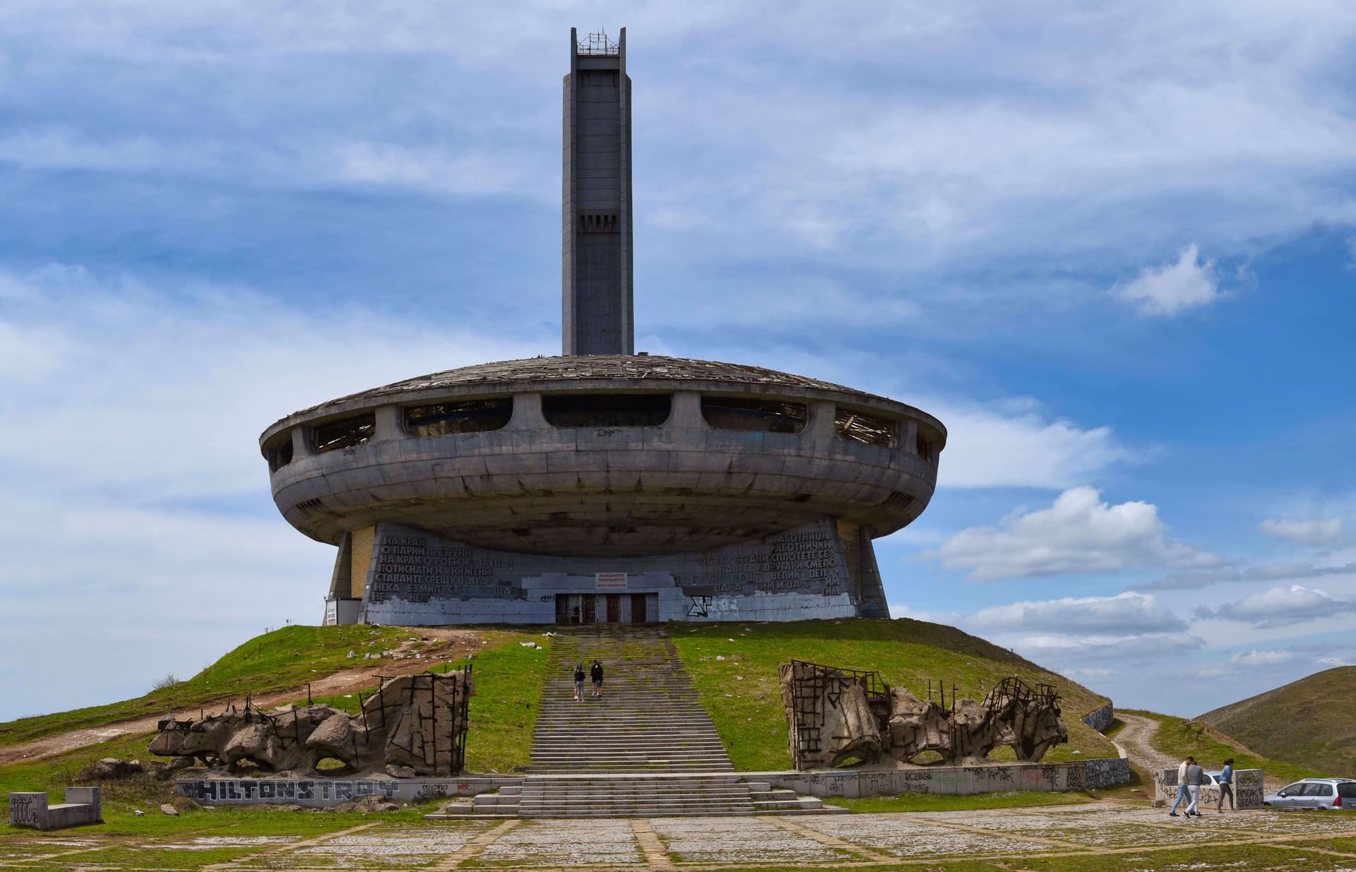
The pedestrian route connecting the Shipka Pass with the Buzludzha mountain huts is one of the most pleasant, easy, and historically rich trails in the Central Balkan Mountains (Stara Planina). The track is an official section of the legendary Kom Emine national long-distance trail, making it perfect for weekend getaways, family hikes, and beginner mountaineers. Since the path winds almost entirely through a cool, dense beech forest, the trek is highly comfortable and ideal even during the hottest days of summer. Key Trail Parameters and Essential Info: - Starting Point: The large parking lot at the foothills of Mount Shipka (near the majestic Monument to Liberty). - Ending Point: The meadows between the two Buzludzha mountain huts. - Difficulty Level: Easy (no dangerous or technically advanced sections). - Terrain: Mixed. The trail consists of 50 percent dirt forest tracks and 50 percent asphalt or paved stone roads. - Trail Markings: Red strip markings (requires extra attention at certain points, especially when entering or exiting the main road). - Drinking Water: There are no natural water springs along the forest path. You can buy bottled water at the shops near Shipka Pass, and a fresh public drinking fountain is available at the parking lot below the small Buzludzha hut. Detailed Step-by-Step Route Description Stage 1: From Shipka Pass via the Russian Monument The trek begins at the main parking lot of the Shipka Pass, heading towards Buzludzha. After about 150 meters, turn right onto the road that climbs towards the Monument to Liberty on Mount Shipka. This approach is much more enjoyable and cuts out most of the vehicle traffic. The path soon reaches the large Russian Monument. Right between the historical cannons surrounding the monument, a clear forest path begins, descending through the woods and leading back to the main asphalt road between Shipka and Buzludzha in less than 10 minutes. Stage 2: The Critical Junction and Forest Incline After stepping onto the asphalt, walk along the road for about 100-150 meters until you reach one of the most critical navigation points of the journey. You will see a junction where a dirt road branches off to the left. It is important not to take this dirt road. The official hiking trail also turns left, but roughly 50 meters further down past the actual junction. From here on, navigation is straightforward. Enter the pleasant forest path and begin a gradual, steady uphill climb. Occasionally, beautiful glimpses of the Buzludzha peak appear through the tree branches. After about 30 minutes of light hiking through the woods, you will reach a well-signposted junction where the route continues to the left. The incline then turns slightly downhill, and 15 minutes later, the trail emerges back onto the main asphalt road. Walk along the pavement for just 20 meters, then immediately rejoin the forest path on the same left side of the road. Stage 3: Across Mount Gradishtitsa to the Torches Monument The route starts climbing gently again for about 15-20 minutes, leading to the small summit of Mount Gradishtitsa at 1318 meters above sea level. Around this high point, an expansive view of the Buzludzha peak opens up briefly. The trail then slopes downhill once more and arrives at the asphalt road after 15 minutes. From this point forward, you will walk strictly along the asphalt road for the next 1.5 km (about 20-30 minutes), paying close attention to passing cars. The road leads straight to the massive parking lot at the base of Mount Buzludzha, where the famous monument featuring two hands holding torches stands, widely known as the Torches Monument (Monument Faklite). Stage 4: Reaching the Final Destination at the Huts If you wish to climb straight to the summit of Mount Buzludzha and explore the main monument structure, take the path leading to the left. To complete the main trek, however, continue following the road. After 350 meters, turn left onto a wide, paved stone path. Within 10-15 minutes, this path will guide you straight to the open meadows located between the two popular local mountain huts: Small (Old) Buzludzha Hut: Accessed via wooden stairs heading up to the left, located just before reaching the meadow. Large (New) Buzludzha Hut: Reached via a clear path on the left side, located just after the meadow, right before the trail rejoins the asphalt road.
Stara Zagora
2.4 km away

Stara Zagora
2.8 km away

Gabrovo
2.9 km away
s.Shipka - h.Buzludzha is located in Stara Zagora, Bulgaria.
s.Shipka - h.Buzludzha is most easily reached by car. Use the coordinates above to navigate, or open the location in OpenStreetMap or your preferred maps app for turn-by-turn directions. Public transport options vary by region — for remote destinations a rental car gives the most flexibility.
s.Shipka - h.Buzludzha is best walked from May through October, when the trail is clear of snow and weather is generally stable. Summer middays can be hot at lower altitudes — start early. Winter walking requires proper gear and route knowledge.
Suitability depends on the specific route. Bulgarian trails range from paved family-friendly paths to multi-day high-mountain crossings. Check the length, elevation gain, and surface before setting off. Sturdy footwear, water, and a basic map (offline or paper) are essential even on short walks.
