MestalaMestala
HomePlacesMapTripBlogAboutFAQ
EN|БГ

Discover Bulgaria with Mestala.

AboutFAQLicensePrivacy
HomePlacesTrailsEco trail Borov Kamak waterfall
Eco trail Borov Kamak waterfall

Eco trail Borov Kamak waterfall

TrailsVratsaCoordinates: 43.15791, 23.50490
View on OpenStreetMapGet directions

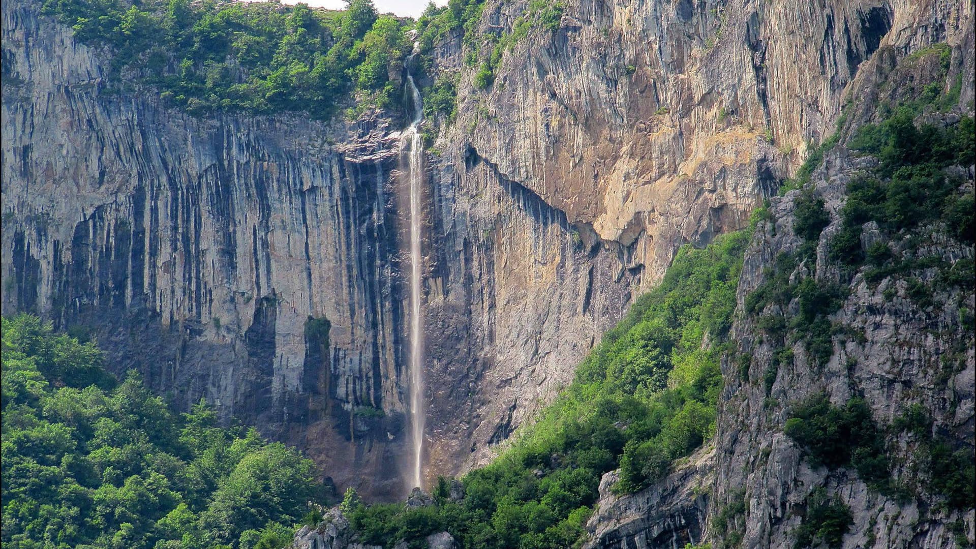
Also known as the Zgorigrad Eco-trail or the Borov Kamak Eco-trail, the Vratsa Eco-trail is one of the most exciting, scenic, and adventurous hiking routes in Bulgaria. Located inside Vratsa Balkan Nature Park, the trail begins just above the mountain village of Zgorigrad (west of Vratsa) and ascends along the Leva River canyon to reach the majestic Borov Kamak Waterfall (65 meters high).

Equipped with numerous wooden bridges, handrails, ladders, and marked with red-pink trail blazes, the path promises an unforgettable alpine experience.

Traversing the Leva River Canyon

  • Trail Origin & History: Starting along the left bank of the Leva River, the trail passes the historical area of the former Plakalnitsa mine tailings dam, site of a tragic 1966 dam breach. Today, the area is entirely safe, restored, and surrounded by lush greenery.
  • The Canyon Bridges: Entering the gorge, the path crosses the Leva River multiple times via wooden footbridges—including a stepped bridge suspended 15 meters above the rushing waters. The river forms natural cascades and clear stone pools, ideal for cooling off during hot summer days.
  • Borov Kamak Waterfall: After approximately 1.5 hours of steady climbing, hikers reach the base of the 65-meter Borov Kamak Waterfall. A designated rest area with wooden benches sits near the base, and adventurous hikers can walk along the cliff shelf directly behind the roaring water curtain.

Summit Views & Connecting Trails

A steep ascent via vertical wooden ladders leads to a panoramic viewing platform directly above the waterfall crest, opening breathtaking vistas over Zgorigrad, the Vratsata Pass cliffs, and the surrounding peaks.

Continuing another 15 minutes leads to a spacious meadow featuring a shelter and picnic area. From here, hikers can choose three options:

  • Continue hiking toward Parshevitsa Hut (approx. 1.5 hours).
  • Follow the ridge trail to Okolchitsa Peak (approx. 4 hours).
  • Return along the same path back down to Zgorigrad.

Flora & Fauna

The humid canyon microclimate supports rich biodiversity—visitors frequently spot fire salamanders, stag beetles, rhinoceros beetles, black woodpeckers, and rare butterflies along the trail, alongside wild strawberries during early summer.

Useful Visitor Information

  • Starting Point: Just above Zgorigrad village (8 km west of Vratsa).
  • Hiking Time: Approx. 1.5 hours to the waterfall (one-way); 3.5 to 4 hours round-trip.
  • Difficulty Level: Moderate to Advanced. Features 20-degree slopes and nearly vertical climbs up wooden ladders.
  • Safety Warning: This trail is not recommended for young children or carriers, as wooden steps and wet rocks can become very slippery after rainfall. Sturdy hiking boots are essential.
  • Trip Tip: Combine your waterfall trek with a scenic drive through the sheer cliffs of the Vratsata Pass, a tour of Ledenika Cave, or a stop at Parshevitsa Hut to sample local mountain cheeses.

7-day forecast

Weather data from MET Norway

Nearby Places

Boriev kamak
Mountains

Boriev kamak

Vratsa

0.7 km away

Vratsa - Okolchitsa - Parshevitsa Hut
Trails

Vratsa - Okolchitsa - Parshevitsa Hut

Vratsa

1.7 km away

Parshevitsa Hut - Okolchitsa Hut
Trails

Parshevitsa Hut - Okolchitsa Hut

Vratsa

2.2 km away

Zgorigrad
Settlements

Zgorigrad

Vratsa

2.6 km away

More to explore

Parshevitsa Hut - Okolchitsa Hut
Trails

Parshevitsa Hut - Okolchitsa Hut

Vratsa

Eco trail White Rocks
Trails

Eco trail White Rocks

Vratsa

Vratsa - Okolchitsa - Parshevitsa Hut
Trails

Vratsa - Okolchitsa - Parshevitsa Hut

Vratsa

Emen Canyon
Trails

Emen Canyon

Veliko Tarnovo

Read more in our travel guides

God's Bridge & Skaklya: Walking the Vrachanski Balkan

God's Bridge & Skaklya: Walking the Vrachanski Balkan

A guide to the Vrachanski Balkan Nature Park: the God's Bridge rock arch near Lilyache, the seasonal Skaklya waterfall above Vratsa, the Borov Kamak eco-trail, and when in spring to time the water.

9 August 202610 min read

Frequently asked questions

Where is Eco trail Borov Kamak waterfall located?

Eco trail Borov Kamak waterfall is located in Vratsa, Bulgaria.

How do I get to Eco trail Borov Kamak waterfall?

Eco trail Borov Kamak waterfall is most easily reached by car. Use the coordinates above to navigate, or open the location in OpenStreetMap or your preferred maps app for turn-by-turn directions. Public transport options vary by region — for remote destinations a rental car gives the most flexibility.

What is the best time to visit Eco trail Borov Kamak waterfall?

Eco trail Borov Kamak waterfall is best walked from May through October, when the trail is clear of snow and weather is generally stable. Summer middays can be hot at lower altitudes — start early. Winter walking requires proper gear and route knowledge.

Is Eco trail Borov Kamak waterfall suitable for beginners?

Suitability depends on the specific route. Bulgarian trails range from paved family-friendly paths to multi-day high-mountain crossings. Check the length, elevation gain, and surface before setting off. Sturdy footwear, water, and a basic map (offline or paper) are essential even on short walks.